As one of Nebraska's biggest cities, Omaha has its share of urban sprawl, but spend a little time in town and find museums, pleasant parks, plenty of places to tuck into for an Omaha steak and somewhat unexpectedly, an indoor rainforest.
Closed to ATV's and motorized vehicles over 50" in width except snowmobiles. No restrictions to motorbikes.
Closed to all motorized vehicles 3 weeks prior to the start of elk rifle season until the end of elk rifle season.
This trail follows the ridge above the Green Monarchs and offers panoramic views of Lake Pend Oreille and provides access to Teepee Gulch Trail 105 and Schafer Peak Trail 68.
There is adequate parking at the trailhead for horse trailers.
Details
Length:
4.3 miles
Difficulty:
Difficult
Time:
2 - 3 hours
Trailhead Elevation:
2200
Useful Map(s):
USGS: Packsaddle Mtn. SE
Map + Directions
Basic Directions
From Sandpoint take Hwy 200 east 25 miles to Clark Fork; turn right onto Steven's Street and cross the Clark Fork River; turn right and go 2.5 miles to Johnson Creek Road 278; take Road 278 approximately 7 miles; turn right on Road 278. The trail starts here.
Below are the Free Visitor Guides for Lake Pend Oreille / Sandpoint. More Visitor Guides are available in Nebraska. Click here to view them all!
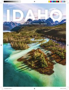
Visit Idaho Idaho
Visit Idaho
IdahoStart planning your Idaho adventure. Vacation is more than just scenery; it’s about making life long memories. Download or order the free Idaho Travel Guide here. Request this Free Visitor GuideRequested!You're all set! Complete the form below to receive your guides by mail.
Switch to Mobile Browser Mode
We offer a compact version of Go-Nebraska for mobile users, allowing you to access just the information you need on the road. Of course, you can still use the full version of Go-Nebraska on your mobile device just as you can on your desktop.