As one of Nebraska's biggest cities, Omaha has its share of urban sprawl, but spend a little time in town and find museums, pleasant parks, plenty of places to tuck into for an Omaha steak and somewhat unexpectedly, an indoor rainforest.
The trail takes off from the end of the road and climbs toward the Continental Divide. Little Cochetopa creek parallels the trail. Fishing, for brook trout, is especially good in the beaver ponds. This trail is a favorite for a leisurely day of fishing.
The trail intersects with the Colorado Trail about .5 miles past Chipeta Mountain. Hikers can travel south via the Colorado Trail/Continental Divide trail to the summit of Marshall Pass.
Lightning and afternoon thunderstorms are common in the Colorado high country. Keep an eye on the weather and if a storm is looming, head for lower ground.
Details
Length:
4.5 miles
Difficulty:
Intermediate
Time:
3 - 4 hours
Trailhead Elevation:
10333
Elevation Range:
10333 feet to 11960
Elevation Change:
1627
Season:
Summer to Fall
Map + Directions
Basic Directions
From Poncha Springs travel west on US Highway 50 for 2 miles. Turn left off the highway onto County Road 210. Stay on CR 210 for 7.25 miles. The last 3.25 miles are rough and require 4-wheel drive.
Below are the Free Visitor Guides for Salida. More Visitor Guides are available in Nebraska. Click here to view them all!
Chaffee County Central Colorado
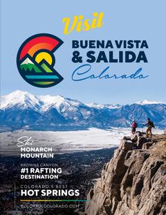
Chaffee County
Central ColoradoMore than 100 miles of the Arkansas River and her tributaries flow through the heart of Chaffee County, gracing both Salida and Buena Vista with her beauty and world-renowned whitewater, fly-fishing, scenery and river festivals. Request this Free Visitor GuideRequested!You're all set! Request a few more Visitor Guides, or complete the form below to receive your guides by mail.
We offer a compact version of Go-Nebraska for mobile users, allowing you to access just the information you need on the road. Of course, you can still use the full version of Go-Nebraska on your mobile device just as you can on your desktop.